
You are here
Day Two, Friday 10th June
Great Yarmouth 10/6
7am: 12c WD 339deg WS 4kt VIS 7km RAIN 0%
1pm: 12c WD 18deg WS 9kt VIS 10km RAIN 0%
At 06:30, as we get up, the four knots of wind forecast seems optimistic, there is hardly a breath. We therefore have a cup of tea before setting off. By 07:10 we are refreshed and the awning is stowed ready to depart. There is now a hint of the forecast north westerly breeze, so we quant out onto the Mere, where, clear of the trees, there is enough wind to sail. We moor to a mud weight, hoist sail and are off. Today’s plan is to visit the next limit of navigation, West Somerton, and then sail down to Yarmouth Yacht Station, ready to make the passage through Yarmouth the next morning. Yarmouth is notorious for its strong tides, and a passage through can only be undertaken at slack water, about an hour and a half after low water. Slack water today is too late to reach a safe mooring beyond Breydon Water by sunset, so we will moor at the Yacht Station and go through on the morning tide. One result of this is that we have time to spare. There is no advantage to being at Yarmouth before slack water, and there is no time, if we are to go through Yarmouth in the morning, too reach any further navigation limit in the northern rivers. So before we set off down Meadow Dyke, there is time for David to hone his helmsman’s skills in the expanse of the Mere. With the wind in the north, the trip down Meadow Dyke, Heigham Sound and Candle Dyke is straightforward and David sails the boat downwind through the Sound.


We turn up river at the entrance to Candle Dyke, and almost immediately pass through the very primitive hand operated swing bridge at Martham Ferry. This bridge is normally open, but the uninitiated need to be aware of a sizeable concrete slab on the left bank. At certain states of tide this can be underwater and invisible. We pass this hazard without incident and carry on across Martham Broad. Martham Broad is reed covered such that the river feels no wider than on the approach, but one the way across there are occasional glimpses of open water beyond the reeds. These areas, inaccessible to boats, are a haven for birds.
The approach to West Somerton is due east. This means that with the north wind, it will be a reach both ways. However, the river is narrow and there is no room to turn except right at the end. We intend to turn and head straight back. I have stopped here on a previous occasion and there is a pleasant pub a short walk away, but we haven’t yet had breakfast.


We turn at the end of the river at 09:40, thereby achieving navigation limit number four, and head off back across Martham Broad. Just below the broad we find a pleasant bit of bank and moor up for breakfast. Jon has planned the catering well, and we enjoy the first of many traditional breakfasts of bacon, egg and sausage, washed down with copious draughts of tea.
Again we pass Martham Ferry and with the wind behind us, we make rapid progress to Potter Heigham, where once again we must pass under the bridges. There is plenty of mooring for masting and we pass through the first, modern bridge then quant on down to the mediaeval arch.

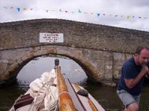
The approach to the old bridge is always difficult. The flow is constrained to the small arches and there are unpredictable eddies. Also motor cruisers and day boats often have no idea of giving way to an un-powered craft.
Anyway, we fit neatly through the centre of the arch and carry on down to moor just below Herbert Woods basin to raise the mast.


With no pressure on time we decide to moor up for lunch. Our chosen spot is at the entrance to Womack Water, where a leisurely break is accompanied by a stroll up to the yard to pick up a buoyancy aid for Jon. In the hurry to get away we had forgotten to collect one before departure.
Continuing down river we pass Thurne Dyke with its white painted windmill, a landmark from many miles away. Moored at the dyke entrance is one of the many yachts named Teasel, after the boat featured in Arthur Ransome's "Coot Club". We feel slightly superior as Lullaby actually played the part of Teasel in a BBC film some years ago.
Just below the dyke we join the river Bure at Thurne Mouth. From here the river downstream is much wider, but he tide is now stronger and will increase yet more as we draw near to Yarmouth.
Less than three miles below Thurne Mouth is the road bridge at Acle. This is a big, wide bridge and there are no worries about fitting through. The problems here can occur because parts of the river are too deep to quant. I have also had a situation here when it has been impossible to quant against the wind, and we have had to tow through, wading on the shallow foundation of the bridge abutment to pull the boat along. Today we have no such worries, with the tide and a moderate breeze behind us. Our only concern is arriving at Yarmouth too early. If the tide is still strong it will be impossible to get ashore with a mooring rope.
Whilst we are moored up for the bridge I make a call to the Yacht Station. I explain my concern and they confirm that they can be available to take a line and it will be OK to arrive early. It is as well to check; normally the Yacht Station staff seem to assume that the crew of Hunter’s boats are unlikely to need assistance and will leap to the aid of a motor cruiser instead. This is probably a valid approach as we do tend to be aware of the potential problems. I would certainly not be there until slack water without the assurance of confirming that they would be to hand.
So with no reason to delay, we are on our way shortly after 18:00 and we are soon past Stokesby with its wonderful pub, The Ferry Inn. (The ferry itself ceased many years ago). Below Stokesby are some of the most desolate reaches of all the rivers. This feeling is heightened because one is always there as the tide is low and the horizon is limited by reeds and mudbanks. Go aground here and you have only moments to get off if you’re not going to be stuck until the tide rises.
We carry on through the reeds and marshes with the only landmarks being the Stracey Arms (It will always be known as the Stracey Arms, even though it has been renamed, after all it’s on the Hamilton’s chart). It must say something that I can’t even recall what it’s now called. Below here the only landmarks are the isolated buildings of Six Mile House, Mautby Marsh Farm and Three Mile House. At Marina Keys I ring the Yacht Station to warn them that we are approaching. 19:30 sees us coming alongside at the Yacht Station. The tide is still very strong, but with both wind and tide behind us, we are able to turn up into them both as we come alongside and throw our lines to the Yacht Station staff who are waiting for us ashore.
We are swiftly made fast, and I sort out extra ropes to use as springs. This arrangement allows the boat to lie comfortably alongside whichever way the tide is flowing and with enough slack for the tidal rise and fall (several feet).
Once everything is stowed, we walk down to the White Swan Inn. The riverside parking is a mass of gleaming chrome as a huge party of bikers have descended on the pub. Much as we enjoy the company of bikers, the queues at the bar are massive, so Jon returns to the boat to cook whilst David and I take a walk down as far as the railway station, where we can look out over Breydon Water and I can explain how we will make our trip through in the morning.
We return to the boat where an excellent meal is awaiting. This is washed down with a bottle of wine and we turn in for sleep. The only thing we miss is a shower; the yacht station showers are closed as there is new laid wet concrete on the step in front of them.
|
Yacht Mileage |
25½ |
|
Navigation Limits |
1 |
- Printer-friendly version
- Log in to post comments