
You are here
Day Three, Saturday 11th June
Great Yarmouth 11/6
7am: 10c WD 311deg WS 4kt VIS 18km RAIN 0%
1pm: 11c WD 346deg WS 9kt VIS 22km RAIN 35%
Our night’s sleep has been much disturbed by a group of young people on two nearby motor cruisers, who have been drinking and making noise until well into the early hours. We, together with the yacht station staff, gain some small sense of satisfaction as we converse loudly whilst picking our way through the abandoned beer cans and other debris that litter the bank.
Rather than hoisting sail, preparation consists of lowering the mast ready to pass under the two low bridges. In an un-powered yacht, this can only be done at slack water, when there is virtually no tide. We cast off at 08:30 and quant down under the bridges. I have already telephoned the Breydon Water lifting bridge to ask for a lift. They will be looking out for us. Quanting down this bit of the Bure is easier than it used to be. Silt deposits mean that the quant will actually reach the bottom and there is no need to rely on paddling with mops, frying pans and the dinghy oars. The oars are however, aboard the boat in case of need.
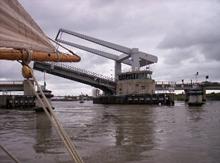
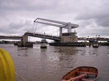
Immediately below the second bridge are three steel and wooden “dolphins.” These provide a mooring from which to raise the mast and hoist sail. We moor up to the second, being very careful to position the fenders to protect the boat from the barnacle encrusted rusty metal. Mast and sail go up and we cast off for the few hundred yards to the lifting bridge. True to their word, the bridge crew are ready. We see the traffic stop, the siren is sounding and as we round the marker post on to Breydon Water, the span begins to rise. It’s a great feeling to be holding up the bypass. With the brisk north-west wind we are approaching the bridge too fast so we have to take a turn back whilst it finishes opening, but soon we are through and on our way across Breydon Water. Crossing Breydon is a unique experience in Broads sailing. The channel, marked by posts, is wide enough for good long tacks, although today we can cross on a fine reach and the water spilling over the mud flats as the tide rises leads to a feeling of being out on open water. The banks are a long way away.
The 4½ miles pass quickly and it is decision time. The Yare or the Waveney? With the north west wind persisting we will have an easier trip up the Waveney, and if the wind goes south, as is likely over the next day or two the trip back will be easy as well. So we turn left and pass Burgh Castle roman fort and the marina. We continue up the reed lined river to the first real civilisation at St Olaves. Here a low bridge crosses the river. The tide is even stronger here than at Acle, and again there is no certainty of touching bottom with the quant. We moor up just below the bridge and after dropping the mast we take a short trip ashore to visit the quaint, antiquated village shop. We are out of luck today as the shop is closed so we return to the boat and make our way through the bridge. The moorings upstream belong to the village pub, The Bell Inn. I know from previous experience that the food and beer are both excellent, but today we are going straight on. A sign requests that boats moor stern on to save space, but that is not an option for us, and besides, the moorings are not busy. We moor facing downstream so that we are head to wind and tide, raise the mast, make sail and we are away. Just outside St Olaves is the entrance to New Cut, an artificial channel linking to the river Yare at Reedham. It is just past the entrance to the Cut that disaster strikes. Jon, at the helm, is heading up what should be a wide and open river when there’s a loud crash and shake and we come to a halt. We have hit a dredging platform moored such that it sticks out into the river.
We push ourselves free and I make a quick damage assessment. The rubbing strake has been torn and the chain plate for the forward shroud has been ripped from the hull. The jib boom is also split. It is clear that we will need to call the boatyard to arrange a repair. The problem is where to moor up? St Olaves is the nearest place, but we would need to go back against the wind and tide. With the broken shroud we dare not sail to windward on the port tack. A look at the map shows public moorings just below the railway swing bridge at Somerleyton. It is all downwind and we will be able to turn up into wind to moor. There is also vehicle access for the yard’s van. With this plan in mind I make the difficult call to the yard. Graham agrees that it is the best option and says that they will be with us as soon as possible, but that there are some jobs to finish in the yard before they leave.
We make Somerleyton without further incident, moor up and have lunch. With a substantial wait for the repair, David and I decide to venture up to the Dukes Head for a couple of excellent pints. Jon elects to remain on board. Refreshed, David and I return to the boat. The gas is lit under the kettle and it is nicely boiling when Graham and his colleague from the yard arrive. They waste no time in setting to work. The holes are filled with resin. The chain plate is re-fixed and a new section of rubbing strake is fashioned out of a piece of mahogany. The jib is attached to a new boom. It is fascinating to watch true craftsmen at work. By 16:30 all is done and there is no sign of the damage other than some sticky tape over the resin to keep it dry until it sets.
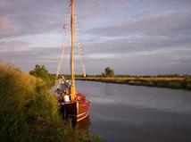
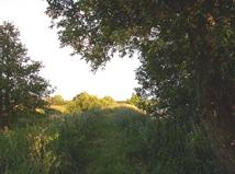
We set off again and the swing bridge duly opens to let us through. We would like to make Beccles tonight, but with the tide now against us we make slow progress to the mouth of Oulton Dyke. Beyond the Dyke progress slows even more as the wind dies and in less than three miles we are forced to give up. We find a pleasant mooring on the north bank just below Castle Mill and away from all civilisation, with just a rural footpath along the bank.
A probe with the quant shows that the water on this bank is fairly shallow. We should be OK, but I resolve to check as we approach low water at 23:00. It turns out that such caution is unnecessary and there is plenty of depth.
|
Yacht Mileage |
17 |
|
Navigation Limits |
0 |
- Printer-friendly version
- Log in to post comments